George Pearson Centre opened in 1952, originally built for tuberculosis patients. Now it is home to people with a variety of disabilities. When Pearson was built in the area known as Marpole, the neighbourhood was a close-knit community.
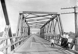
This was before the current Oak Street Bridge was built. During planning, it was called the “New Marpole Bridge”, as it was replacing the “Old Marpole Bridge”, pictured above. In 1957, after the completion of the Oak Street Bridge that linked Marpole with Richmond, the neighbourhood changed rapidly. The now busy Oak Street split Marpole in two, and the previously thriving business districts along Hudson Street and Marine Drive quickly declined.
Pearson is situated on the boundary between Marpole and Oakridge neighbourhoods. In May 2011, the City of Vancouver directed its staff to begin planning for the redevelopment of these areas, including the Cambie Corridor. The plan over the next few decades is to increase density so 15,000 more people will be living along the Cambie corridor.
A recent news article on CBC “House values skyrocket in Vancouver’s Cambie corridor” reports that houses along Cambie have been selling for three times their assessed value — they say 10 homes on Cambie Street near 41st Avenue just sold for $3.4 million each. Pearson is located just a bit further south, between 57th and 59th Avenues.
As part of the Marpole community, the residents at Pearson are wondering what the future will hold for them in this changing neighbourhood — only time will tell.